Wikipedia:Graphics Lab/Map workshop/Archive/May 2024 Source: en.wikipedia.org/wiki/Wikipedia:Graphics_Lab/Map_workshop/Archive/May_2024
| This is an archive of past discussions on Wikipedia:Graphics Lab, for the period 2024. Do not edit the contents of this page. If you wish to start a new discussion or revive an old one, please do so on the current main page. |
 | Archives of 2024: January, February, March, April, May, June, July, August, September, October, November, December |
Fixing river basin of the Jing He and tributaries
- Article(s)
- Jing River, plus as of yet nonexistent articles of its tributaries.
- Request
- The main course of the Jing River is incorrectly shown on the current File:weirivermap.png. As seen here, the main fork of the river curves westward, and runs parallel to its tributary, the Hong He; the part currently marked as the main fork is actually the Malian He. I would be extremely thankful if someone could fix that up on the existing maps there, and especially if someone could make a map showing the Jing River basin, including its three major tributaries. Generalissima (talk) (it/she) 21:49, 4 May 2024 (UTC)
- Discussion
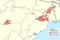
Please make Bosnia and Herzegovina orange
{{resolved}}

- Article(s)
- de:Stolpersteine and many more
- Request
- In April 2024 the first collocations of Stolpersteine in Bosnia and Herzegovina took place. Donna Gedenk wrote an article about it - de:Liste der Stolpersteine in Bosnien und Herzegowina. Can you please make Bosnia and Herzegovina ORANGE, just like all other countries with Stolpersteine. -- 91.141.76.232 (talk) 15:27, 21 June 2024 (UTC)
- Discussion
 Done – Isochrone (talk) 16:34, 21 June 2024 (UTC)
Request
-
 Historic map of Haiti

- Article(s)
- Hinche, Louisiana Creole people, Parsley massacre, White Haitians
- Request
- Vectorise, and replace "Grenzfestlegung 1776" with "Boundary of 1776". It's apparently not an exact translation of the German, but it gets the point across. Note that several letters are overlaid on coastlines; you may have an easier time combining File:Haiti location map.svg and File:Dominican Republic location map.svg, deleting the current boundary, adding the 1776 boundary, and putting some text on. -- Nyttend (talk) 19:46, 29 April 2024 (UTC)
- Discussion
- Note for anyone possibly taking this request, this seems to be a more accurate boundary. – Isochrone (talk) 08:55, 10 May 2024 (UTC)
Map Crusader states 1240-eng.png

Article
- Alice of Champagne (FAC)
Request
- During the FAC review, I was reminded MOS:COLOUR but I have never made or edited maps. Thank you for your assistance in fixing the map. Borsoka (talk)
Borsoka (talk) 02:20, 12 May 2024 (UTC)
Pronouns in Schools
- Article(s)
- Parents' Bill of Rights
- Policy 713
- Transgender rights in Canada
- Preferred gender pronoun
- Request
- Create a map of Canadian provinces with New Brunswick and Saskatchewan in color because they have laws that requires parental consent when students under the age of 16 wish to change their names or pronouns related to gender expression while at school.
- Discussion
- Alberta Premier Danielle Smith has announced plans that will require parental consent when students under 15 years old. Alberta could be colored in orange (For incoming law) while New Brunswick and Saskatchewan can be colored in red (because its the law of the land).
Sources.Muaza Husni (talk) 04:47, 30 March 2024 (UTC) [1][2][3][4] [5][6][7]
- Are you after a map where only those two provinces are coloured? If so, please suggest a name for it and provide the necessary information for Commons (description, categories and structured data). M.Bitton (talk) 23:44, 30 March 2024 (UTC)
- You can do two of the provinces yes, it could be called Pronouns laws in Canadian Schools By province. I don't know what that means necessary information for Commons (description, categories and structured data). The description could be like the title Pronouns laws in Canadian Schools By province, I don't know what categories or structured data means??? Sorry, can you tell me more.Muaza Husni (talk) 03:42, 1 April 2024 (UTC)
- @Muaza Husni: would it be possible for you to have a go at creating it yourself using this base map and the instructions that go with it? M.Bitton (talk) 16:04, 15 April 2024 (UTC)
- @M.Bitton: I don't know how to make it, its too complicated. Sorry.Muaza Husni (talk) 15:26, 21 April 2024 (UTC)
- @Muaza Husni: did you read the instructions? If so, which part did you find complicated? M.Bitton (talk) 15:29, 21 April 2024 (UTC)
- @M.Bitton: Do they have a video that can explain it?, Do I have to download the base map and color it or what? I just don't understnd it. On the the instructions it has on the last section says Provinces and territories and some unique id numbers with it. do I put?, how do I put those unique id numbers on the base map. So many things I don't understand with this. I don't think it would be possible for me creating it myself. I think its better to leave it to a professional. Muaza Husni (talk) 08:56, 15 May 2024 (UTC)
References
- ^ "Saskatchewan joins N.B. In changes to LGBTQ inclusion policy in schools – New Brunswick | Globalnews.ca". Archived from the original on September 2, 2023. Retrieved September 2, 2023.
- ^ "Saskatchewan, New Brunswick naming changes means 'life or death' for trans students, minister says – the Globe and Mail". The Globe and Mail. August 31, 2023. Archived from the original on September 2, 2023. Retrieved September 2, 2023.
- ^ "This teen worries N.B.'s gender identity policy change started a chain reaction". Archived from the original on September 2, 2023. Retrieved September 2, 2023.
- ^ Hantiuk, Paul (September 1, 2023). "This teen worries N.B.'s gender identity policy change started a chain reaction". CBC. Archived from the original on September 2, 2023. Retrieved 3 September 2023.
- ^ https://globalnews.ca/news/10264436/alberta-parental-rights-policy/
- ^ https://www.cbc.ca/news/canada/edmonton/danielle-smith-unveils-sweeping-changes-to-alberta-s-student-gender-identity-sports-and-surgery-policies-1.7101053
- ^ https://edmonton.ctvnews.ca/alberta-to-require-parental-consent-for-name-pronoun-changes-at-school-1.6750498
Munda languages map
-
 Munda languages map

- Article(s)
- Munda languages
- Request
- Could you add District and subdistrict boundary? -- Kaiyr (talk) 17:50, 18 May 2024 (UTC)
- Discussion
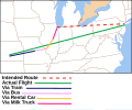
Planes, trains and automobiles route map - GIF to SVG
{{resolved}}
-
 GIF
GIF -
 SVG
SVG


- Article(s)
- Any article this already features on.
- Request
- Would anybody be able to please redraw the above GIF map as SVG? Thanks. Snow Lion Fenian (talk) 13:15, 2 June 2024 (UTC)
 Bumping thread. Snow Lion Fenian (talk) 01:10, 2 July 2024 (UTC)
 - Discussion
- Done TheWanderingTraders (talk) 04:07, 8 July 2024 (UTC)
- @TheWanderingTraders: Nicely done, thanks again! Snow Lion Fenian (talk) 17:16, 8 July 2024 (UTC)
Trump 2016 Republican Party presidential primaries results

0.0–9.9%
10.0–19.9%
20.0–29.9%
30.0–39.9%
40.0–49.9%
50.0%+

0.0–19.9%
20.0–29.9%
30.0–39.9%
40.0–49.9%
50.0–59.9%
60.0–69.9%
70.0–79.9%
80.0%+
- Article(s)
- Donald Trump 2016 presidential campaign
- Results of the 2016 Republican Party presidential primaries
- Request
- I saw this map on John Kasich 2016 presidential campaign, I was wondering can somebody make one for Donald Trump 2016 presidential campaign for his Republican primary Percentage of vote received by Trump by state or territory.Muaza Husni (talk) 09:03, 5 June 2024 (UTC)
References
Here are the result numbers.
- Trump got 24% in Iowa,
- Trump got 35% in New Hampshire,
- Trump got 33% in South Carolina,
- Trump got 46% in Nevada,
- Trump got 43% in Alabama,
- Trump got 34% in Alaska,
- Trump got 33% in Arkansas,
- Trump got 39% in Georgia,
- Trump got 49% in Massachusetts,
- Trumo got 21 in Minnesota,
- Trump got 28% in Oklahoma,
- Trump got 39% in Tennessee,
- Trumo got 27% in Texas,
- Trump got 32% in Vermont,
- Trump got 35% in Virginia,
- Trump got 23% in Kansas,
- Trump got 36% in Kentucky,
- Trump got 41% in Louisiana,
- Trump got 33% in Maine,
- Trump got 13% in Puerto Rico,
- Trump got 43% in Hawaii,
- Trump got 28% in Idaho,
- Trump got 37% in Michigan,
- Trump got 37% in Mississippi,
- Trump got 7% in Wyoming,
- Trump got 46% in Florida,
- Trump got 39% in Illinois,
- Trump got 41% in Missouri,
- Trump got 40% in North Carolina,
- Trump got 36% in Ohio,
- Trump got 46% in Arizona,
- Trump got 14% in Utah,
- Trump got 35% in Wisconsin,
- Trump got 59% in New York,
- Trump got 58% in Connecticut,
- Trump got 61% in Delaware,
- Trump got 54% in Maryland,
- Trump got 57% in Pennsylvania,
- Trump got 63% in Rhode Island,
- Trump got 53% in Indiana,
- Trump got 61% in Nebraska,
- Trump got 77% in West Virginia,
- Trump got 64% in Oregon,
- Trump got 75% in Washington,
- Trump got 75% in California,
- Trump got 74% in Montana,
- Trump got 80% in New Jersey,
- Trump got 71% in New Mexico,
- Trump got 67% in South Dakota.
Muaza Husni (talk) 07:54, 25 June 2024 (UTC)
- @Muaza Husni: Done TheWanderingTraders (talk) 01:25, 9 July 2024 (UTC)
- @TheWanderingTraders: Thank you for making the map.Muaza Husni (talk) 04:26, 10 July 2024 (UTC)
- Marking as {{resolved}}. CMD (talk) 10:42, 10 July 2024 (UTC)
Request - Greeneville in Greene Co in Tennessee Reply
-
 Description of first image
 -

-
 New map


- Article(s)
- Dolly Johnson
- Request
- Hoping for a map that shows the location of Greeneville within Greene County, but that also puts Greene County's location in East Tennessee and nearby states (namely Virginia and North Carolina), to be illustrative for people who may be unfamiliar with American geography. Might want to include Knoxville and Parrotsville as well, as other key cities in Dolly's bio. TY! -- jengod (talk) 16:28, 13 June 2024 (UTC)
- Discussion
- @Jengod: Done TheWanderingTraders (talk) 02:44, 9 July 2024 (UTC)
- The way I just gasped. Thank you so so so much. jengod (talk) 02:46, 9 July 2024 (UTC)
- Marking as {{resolved}}. CMD (talk) 10:43, 10 July 2024 (UTC)
Requesting update to File:PDC World Cup of Darts Map.svg
-
 The current map, outdated to 2021.

- Article(s)
- List of PDC World Cup of Darts teams
- Request
- Requesting someone who knows how to do this sort of thing to update the map on List of PDC World Cup of Darts teams, last updated in 2021. The specific changes that are required are for New Zealand, Latvia, Switzerland, France, Malaysia, Guyana, Iceland, Taiwan, Norway, Bahrain and Croatia to be coloured light blue and for Ukraine, Russia, Brazil and Greece to be coloured in orange. This will match with developments over the 2022, 2023 and 2024 tournaments and will match the key on the article. -- OZOO (t) (c) 13:48, 1 July 2024 (UTC)
- Discussion
- Hi OZOO, please check the file. Best, CMD (talk) 12:56, 7 July 2024 (UTC)
- Only issue I can see is that Corsica is still coloured in orange, rather than blue, otherwise it's great. OZOO (t) (c) 13:51, 7 July 2024 (UTC)
- Got all those Russian islands and missed that. Fixed now, so marking as {{resolved}}. Best, CMD (talk) 04:24, 8 July 2024 (UTC)
- Only issue I can see is that Corsica is still coloured in orange, rather than blue, otherwise it's great. OZOO (t) (c) 13:51, 7 July 2024 (UTC)
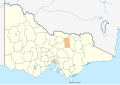
Shire of Delatite map
-
 Map of the Rural City of Benalla
 -
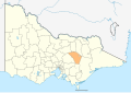 Map of the Shire of Mansfield
 -
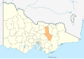 Delatite?


- Article(s)
- Shire of Delatite
- Request
- Could you create a map of the Shire of Delatite? It was an amalgamation of Benalla and Mansfield, so I suppose you'd basically just have to take one of these maps, highlight the area marked on the other one, and remove the border. Nyttend (talk) 11:44, 7 July 2024 (UTC)
- Discussion
- Nyttend A bit rough and ready but does the above work? CMD (talk) 12:17, 7 July 2024 (UTC)
- Looks good, but the attribution is missing on the description page. Nyttend (talk) 13:01, 7 July 2024 (UTC)
- Always appreciate that check, but I do partially blame the upload wizard, with whom I have an uneasy relationship. {{resolved}}
- Looks good, but the attribution is missing on the description page. Nyttend (talk) 13:01, 7 July 2024 (UTC)
North American flags map - Belize and Honduras
{{resolved}}
-
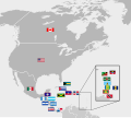
-
 Current flag of Belize


- Article(s)
- Any article this is already on.
- Request
- Can someone please modify the flags of Belize and Honduras on the above map, so that they match the current versions of both countries' flags, also provided above? Thanks. Snow Lion Fenian (talk) 17:23, 7 July 2024 (UTC)
- Discussion
 Request taken. File is done, just waiting on overwriting permissions. TheWanderingTraders (talk) 02:52, 8 July 2024 (UTC)
- @TheWanderingTraders: Great work, and thank you! Snow Lion Fenian (talk) 17:13, 8 July 2024 (UTC)
Cruz 2016 Republican Party presidential primaries results
0.0–9.9%
10.0–19.9%
20.0–29.9%
30.0–39.9%
40.0–49.9%
50.0%+
0.0–19.9%
20.0–29.9%
30.0–39.9%
40.0–49.9%
50.0–59.9%
60.0–69.9%
70.0–79.9%
80.0%+

0.0–9.9%
10.0–19.9%
20.0–29.9%
30.0–39.9%
40.0–49.9%
50.0%+
- Article(s)
- Ted Cruz 2016 presidential campaign
- Results of the 2016 Republican Party presidential primaries
- Request
- They have these maps on John Kasich 2016 presidential campaign and Donald Trump 2016 presidential campaign, I was wondering can somebody make one for Ted Cruz 2016 presidential campaign (who came in second place in the 2016 primary) for his Republican primary Percentage of vote received by Cruz by state or territory.
Here are the result numbers.
- Cruz got 27.64% in Iowa,
- Cruz got 11.63% in New Hampshire,
- Cruz got 22.33% in South Carolina,
- Cruz got 21.30% in Nevada,
- Cruz got 21.09% in Alabama,
- Cruz got 36.37% in Alaska,
- Cruz got 30.50% in Arkansas,
- Cruz got 23.60% in Georgia,
- Cruz got 9.50% in Massachusetts,
- Cruz got 29.04% in Minnesota,
- Cruz got 34.37% in Oklahoma,
- Cruz got 24.71% in Tennessee,
- Cruz got 43.76% in Texas,
- Cruz got 9.61% in Vermont,
- Cruz got 16.69% in Virginia,
- Cruz got 45.90% in Maine,
- Cruz got 47.50% in Kansas,
- Cruz got 31.57% in Kentucky,
- Cruz got 37.83% in Louisiana,
- Cruz got 8.76% in Puerto Rico,
- Cruz got 32.23% in Hawaii,
- Cruz got 45.44% in Idaho,
- Cruz got 24.68% in Michigan,
- Cruz got 36.12% in Mississippi,
- Cruz got 70.94% in Wyoming,
- Cruz got 17.14% in Florida,
- Cruz got 30.23% in Illinois,
- Cruz got 40.63% in Missouri,
- Cruz got 36.76% in North Carolina,
- Cruz got 13.31% in Ohio,
- Cruz got 27.61% in Arizona,
- Cruz got 69.46% in Utah,
- Cruz got 48.20% in Wisconsin,
- Cruz got 14.53% in New York,
- Cruz got 11.70% in Connecticut,
- Cruz got 15.90% in Delaware,
- Cruz got 18.97% in Maryland,
- Cruz got 21.67% in Pennsylvania,
- Cruz got 10.4% in Rhode Island,
- Cruz got 36.63% in Indiana,
- Cruz got 18.44% in Nebraska,
- Cruz got 8.97% in West Virginia,
- Cruz got 16.63% in Oregon,
- Cruz got 10.81% in Washington,
- Cruz got 9.50% in California,
- Cruz got 9.36% in Montana,
- Cruz got 6.22% in New Jersey,
- Cruz got 13.31% in New Mexico,
- Cruz got 16.97% in South Dakota.
Thanks.Muaza Husni (talk) 13:28, 10 July 2024 (UTC)
- @Muaza Husni: Technically Done - this file has already been created, see this category on Commons for others files you may want to see if they have already been created. Hope this helps, TheWanderingTraders (talk) 03:02, 13 July 2024 (UTC)
- @TheWanderingTrader: Thanks again.