Wikipedia:Graphics Lab/Map workshop/Archive/Jun 2013 Source: en.wikipedia.org/wiki/Wikipedia:Graphics_Lab/Map_workshop/Archive/Jun_2013
Stale
[edit]Bad day
[edit]-
 Canoe boo-boo

I made this image to highlight this park. The circle doesn't show well in the infobox at w:Syringa Provincial Park though. I spelt the park wrong in the file name. Should I just do a darker circle or is it easy to make a map that shows the borders? Here are some links that show the location better.--Canoe1967 (talk) 19:02, 20 April 2013 (UTC)
- Park website
- .pdf map
Google BC parksMoved to commons map shop.Canoe1967 (talk) 20:06, 21 April 2013 (UTC)
Marathon route maps
[edit]Please visit Wikipedia:Village pump (proposals)#Marathon route maps
Thanks, Anna Frodesiak (talk) 15:36, 17 April 2013 (UTC)
Reposted here from Wikipedia:Village pump (proposals)#Marathon route maps:
|
Qualifications:
Job description:
Salary:
These major articles and others have no route maps--just pictures of people running: See also: Talk:Boston Marathon#Map Please help. Thank you. :) Anna Frodesiak (talk) 12:29, 17 April 2013 (UTC) |
(Some discussion occurred at Wikipedia:Village pump (proposals)#Marathon route maps but should be continued here.) Anna Frodesiak (talk) 03:35, 19 April 2013 (UTC)
- I've managed to create a map for London: File:London Marathon.png. If there are any mistake or improvements than can be made, do ask. --[[ axg ◉ talk ]] 19:05, 24 April 2013 (UTC)
Virginia relief location map
[edit]
-
 Example: North Carolina relief location map

Article(s): most any small-area/point-based physical geography article of Virginia (e.g. Mount Rogers, Crabtree Falls)
Request:
- Several states have physical geography location maps (example shown above), which are more apt for articles on point-based physical and natural subjects such as mountains, islands, state parks, etc. than the map of purely political boundaries which currently exists. I humbly request one for the Commonwealth of Virginia. -- Morgan Riley (talk) 01:59, 24 April 2013 (UTC)
Graphist opinion(s):
Resolved
[edit]Illinois locator map
[edit]-
 Locator map of Illinois

Article(s): Almost one thousand articles currently use this map!
Request:
- Please add a line showing the boundary between two counties. I've just noticed that the boundary between Shelby County and Montgomery County is missing, making the two appear to be one county. File:Map of Illinois highlighting Shelby County.svg and File:Map of Illinois highlighting Montgomery County.svg will show you where the border should be placed. Nyttend (talk) 07:18, 30 May 2013 (UTC)
Graphist opinion(s):
 Done (refresh the cache if the change not seen) Hellerick (talk) 02:41, 31 May 2013 (UTC)
West and East Malaysia
[edit]-
 West Malaysia
(Peninsular Malaysia) -
 East Malaysia
(Malaysian Borneo) -
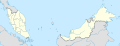 Map of Malaysia. Base map that could be used in making two separate maps
 -
 Kalimantan, Indonesia


Article(s): For Peninsular Malaysia, East Malaysia and other Malaysia-related articles that needs a map
Request:
- Since Malaysia is separated in two by the vast South China Sea, I'll make a request to have two separate maps to be created: for West (1st image) and East (2nd image). Currently there is a combined map of Malaysia (3rd image), I myself can separate it (but not deleting the original) however I'm not that much confident to do so since it needs geographical limits to have it done. Example is the 4th image which had been made (above Kalimantan is Brunei and Malaysian Borneo). Thanks! -- adkranz (talk) 05:45, 2 June 2013 (UTC)
Graphist opinion(s):
![]() Done: Resolved in Wikimedia Commons.
Done: Resolved in Wikimedia Commons.
Location map of Slovenia
[edit]
Article(s): Robidišče; Dragonja, Piran etc.
Request:
- The village of Robidišče is located in Slovenia, but in Robidišče it is depicted as if it was in Italy. The map (or the article) should be corrected so that the settlement's location is displayed correctly. I've also asked for help at the uploader's talk page (here), but the user doesn't know how to rectify this. --Eleassar my talk 07:23, 6 June 2013 (UTC)
Graphist opinion(s):
- This is not a problem of the map, it's a problem of a big red dot on a small map which only seems to be in Italy. As you can see here the dot for Robidišče is shown exactly at the border of Slovenia, that's where the village can be found. NNW (talk) 09:12, 6 June 2013 (UTC)