Wikipedia:Graphic Lab/Map workshop/Archive/Dec 2011 Source: en.wikipedia.org/wiki/Wikipedia:Graphic_Lab/Map_workshop/Archive/Dec_2011
Stale
[edit]Replacing old map with unknown base map
[edit]-
This map has an iffy copyright status and is up for deletion.
Article(s): Prehistory of West Virginia
Request: I just nominated this map for deletion because there is no source for the base map. Could somebody recreate this map, but using a legit base map, so that we don't lose the information? Calliopejen1 (talk) 17:02, 8 October 2011 (UTC)
Graphist opinion(s):
Distribution map of Hallstatt culture in ancient Europe
[edit]-
 Distribution of Hallstatt culture in ancient Europe, per 2001 reference (see file).

Article(s): Hallstatt culture
Request: Upon encountering the above article, I noticed the absence of any map. Upon checking the talkpage, I found reference to the need to update the previously utilised maps. In the time available to me, I did a search via Google books and found a reference for a map portraying the distribution of Hallstatt culture in ancient Europe,[1] which I provided (see above talkpage link). Is it possible to utilise this reference to create an updated version of the map above. I wouldn't advocate altering the above map itself - it is a time-dated reference and thus can be utilised for other purposes. I'm presuming one could take the existing map, copy it, and edit it to incorporate the relevant information from the reference provided. That however is not my area of expertise. Cheers Wotnow (talk) 21:39, 10 October 2011 (UTC)
A ref
[edit]- ^ Piggott, Stuart (2009), "Distribution of Hallstatt culture in ancient Europe", in . (ed.), Ancient Europe, New Brunswick, U.S.A.: Aldine Transaction, p. 180, ISBN 978-0-202-30939-2, retrieved 09 October 2011
{{citation}}:|editor=has numeric name (help); Check date values in:|accessdate=(help)
Another editor suggested taking Piggot's map and augmenting it: "In figure 6 here Gamito has a nice map of Hallstatt stamped pottery distibution and mentions in detail areas of Portugal and Spain as well as Cornwall and western Britain which are not on Piggot's map in the text on the left of the map and in the timelines and maps above this figure which deal with the Iberian peninsula in relation to Hallstatt settlement or cultural expansion. I would say take Piggot's map as a base and augment it with the archaelogical evidence distribution in Gamito's work - requires only a slight extension in Iberia and Britain and maybe Italy too I'd say from her text" (see above talk page link).
Graphist opinion:
Map of the caves Balankancha
[edit]
Article(s): Brazil
Request: Do something with them... Странник27 (talk) 12:34, 13 October 2011 (UTC)
Comment: Guessing you mean this file? Map of cave system. Using google translate I can see that the file is up for deletion. This may be because the file is not free? Are you asking someone here to create a free version of the same file? Del♉sion23 (talk) 16:59, 13 October 2011 (UTC)
- Explanation to not-Russian-speaking users (in fact, resume of the discussion in ru-wiki): there's an unclear (at least for me) court decision that the creation of an indepedent work on the basis of the same cartographical information isn't a copyright violation. (Суд признал, что не является нарушением прав истца – обладателя исключительных прав на творчески созданное картографическое произведение – создание на основе той же исходной информации самостоятельного произведения.) — Preceding unsigned comment added by Ain92 (talk • contribs) 17:51, 19 October 2011 (UTC)
Graphist opinion(s): Что надо сделать с этим файлом? Вектор, или че? А! Я нашла что вы уже попросили вектор в русской графической мастерской: [1] Слушайте, сделать вектор карты не снимает претензий по авторскому праву; карта таже самая остаётся, только в другом формате. Копирайт на ней будет тот же. Бесплатную карту надо либо найти, либо сделать из какого нибудь описания. -MissMJ (talk) 21:28, 18 October 2011 (UTC)
- Обьяснение здесь [2] — Preceding unsigned comment added by Странник27 (talk • contribs) 12:42, 19 October 2011 (UTC)
Qing Dynasty
[edit]
Article(s): History of China, Qing Dynasty
Request: Using the map above, create a map of the Qing Dynasty in 1820 that is similar to maps in articles German Empire(map here:[3] ) or Austro-Hungarian Empire(map here:[4] ). Wave1d6 (talk) 16:20, 23 October 2011 (UTC)
Graphist opinion(s):
Otto von Kotzebue
[edit]
Article(s): Otto von Kotzebue
Request: Translate text into English into different file name... KAVEBEAR (talk) 22:10, 9 October 2011 (UTC)
Graphist opinion(s):
Created Historical Map of Hawaii in 1783
[edit]-
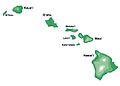 something like this but with a blue ocean and probably make bigger so that you can seem the smaller islands too
 -
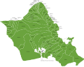
 these are the districts of the Big Islands, don't follow the borders completely just make rough guesses which area was ruled by which three chiefs


Article(s): History of Hawaii
Request: Using the maps of Hawaii on the commons, create a map showing the kingdoms that existed in the year 1783. Niihau and Kauai being one state name Kingdom of Kauai. Maui, Oahu, Molokai, Lanai, Kahoolawe being one state named Kingdom of Maui. Hawaii (island) being called Kingdom of Hawaii (fragmented) with three different colors showing 1. Kamehameha's possessions in the districts of Kona, Kohala, and parts of Hamakua. 2. Keawemauhili's possessions in the districts of Hilo, parts of Puna, and parts of Hamakua. 3. Keōua Kuahuula's possession in the district of Kau and parts of Puna. KAVEBEAR (talk) 19:31, 6 July 2011 (UTC)
- Also is there anybody interested in creating an animation of the Unification of Hawaii?--KAVEBEAR (talk) 21:53, 5 August 2011 (UTC)
- Anybody?--KAVEBEAR (talk) 18:51, 16 October 2011 (UTC)
Society Island Kingdoms
[edit]
Article(s): Kingdom of Tahiti, Kingdom of Huahine, Kingdom of Raiatea, Kingdom of Bora Bora, History of French Polynesia
Request: Create a map for the four different Society Island Kingdoms. Kingdom of Tahiti with Tahiti, Moorea, Tetiaroa, and Mehetia. Kingdom of Huahine with Huahine and Maiao. Kingdom of Raiatea with Raiatea and Tahaa. And the rest of the islands in the west is the Kingdom of Bora Bora. KAVEBEAR (talk) 05:47, 2 September 2011 (UTC)
- Anybody?????????????????--KAVEBEAR (talk) 18:51, 16 October 2011 (UTC)
Graphist opinion(s):
Range map for Spotted eagle ray
[edit]-
 Base map

Reliable source: http://www.iucnredlist.org/apps/redlist/details/39415/0/rangemap
Article(s): Spotted eagle ray
Request: Create a range map according to the provided map source. Regards, SunCreator (talk) 16:05, 26 October 2011 (UTC)
Resolved
[edit]Oahu ahupuaa
[edit]-

-
 Done
Done


Article(s): Ahupuaa
Request: Can someone vectorize this? Thank you.... KAVEBEAR (talk) 01:44, 6 November 2011 (UTC)
Graphist opinion(s):
![]() Done - already done in ill. wkshp. --Sn1per (talk) 22:50, 28 November 2011 (UTC)
Done - already done in ill. wkshp. --Sn1per (talk) 22:50, 28 November 2011 (UTC)
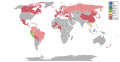
Electronic visas (Australia)
[edit]-
 Map of countries/territories whose citizens can apply for electronic visas to Australia


Article(s): Electronic visas (Australia)
Request: Please can you add Bahrain, Chile, Croatia, Kuwait, Maldives, Oman, Qatar, Saudi Arabia, Turkey and United Arab Emirates to the map in another colour under the category 'Electronic tourist visa' and New Zealand in another colour under the category 'Special Category Visa'. Thank you! Bonus bon (talk) 22:48, 18 October 2011 (UTC)
Graphist opinion(s):
![]() Done. Derfel73 (talk) 11:42, 23 October 2011 (UTC)
Done. Derfel73 (talk) 11:42, 23 October 2011 (UTC)
Angonoka tortoise range on Madagascar map
[edit]-
 base map of Madagascar
 -
 Range map of the angonoka tortoise.


Article(s): Angonoka tortoise
Request: Add the two little bits of native range from http://www.iucnredlist.org/apps/redlist/details/9016/0/rangemap to the base map Regards, SunCreator (talk) 01:15, 31 October 2011 (UTC)
Graphist opinion:
![]() Done. Derfel73 (talk) 13:56, 31 October 2011 (UTC)
Done. Derfel73 (talk) 13:56, 31 October 2011 (UTC)
- Thank you! A bit smaller range then I expected. My problem, maybe that original base map is to big, will await feedback on article. Regards, SunCreator (talk) 01:01, 1 November 2011 (UTC)
Miss International 2010
[edit]-
 Done
Done

Article(s): Miss International 2010
Request: Please make a map of Miss International 2010 participations and results.
- W (Venezuela)
- 1st RU (Thailand)
- 2nd RU (China)
- 4-15 (Costa Rica, France, Germany, India, Japan, South Korea, Peru, Philippines, Puerto Rico, Serbia, Spain, Turkey)
- 16-70 (Aruba, Australia, Bahamas, Belarus, Belgium, Bolivia, Brazil, Canada, Chile, Chinese Taipei, Colombia, Czech Republic, Denmark, Dominican Republic, Ecuador, Finland, Georgia, Greece, Guadeloupe, Guam, Guatemala, Hawaii, Hong Kong, Indonesia, Italy, Jamaica, Kenya, Latvia, Lebanon, Lithuania, Macau, Malaysia, Martinique, Mauritius, Mexico, Mongolia, Nepal, Netherlands, New Zealand, Nicaragua, Norway, Panama, Paraguay, Poland, Russia, Singapore, Slovak Republic, South Africa, Sri Lanka, Sweden, Tahiti, Ukraine, United Kingdom, USA, Vietnam)
Colors :
- W (Dark Blue)
- 1st RU (Light Blue)
- 2nd RU (Dark Green)
- 4-15 (Pink)
- 16-70 (Dark Pink)
- Non-participants (Dark Grey) (Do not add this to ranking box)
I request this map to Derfel73, thanks. DeshintaChandra (talk) 10:45, 31 October 2011 (UTC)
Graphist opinion:
![]() Done. Derfel73 (talk) 15:49, 31 October 2011 (UTC)
Done. Derfel73 (talk) 15:49, 31 October 2011 (UTC)
Miss Earth 2010 map requests
[edit]-
 Done
Done

Article(s): Miss Earth 2010
Request: Please make a map of Miss Earth 2010 participations and results.
- W (India)
- 1st RU (Ecuador)
- 2nd RU (Thailand)
- 3rd RU (Puerto Rico)
- 5-7 (Japan, South Africa, Venezuela)
- 8-14 (Czech Republic, Italy, Netherlands, Russia, Ukraine, USA, Vietnam)
- 15-84 (Australia, Bahamas, Belgium, Bolivia, Bosnia and Herzegovina, Botswana, Brazil, Cameroon, Canada, Cayman Islands, Chile, China, Chinese Taipei, Colombia, Costa Rica, Crimea, Curacao, Denmark, Dominican Republic, Egypt, England, France, French Polynesia, Germany, Ghana, Guadeloupe, Guam, Guatemala, Guyana, Hong Kong, Indonesia, Ireland, Jamaica, Kenya, Korea, Kosovo, Latvia, Lebanon, Luxembourg, Macau, Madagascar, Malaysia, Malta, Martinique, Mauritius, Mexico, Mongolia, Nepal, New Zealand, Nicaragua, Nigeria, Northern Ireland, Norway, Panama, Peru, Philippines, Poland, Romania, Samoa, Scotland, Serbia, Singapore, Slovak Republic, Slovenia, South Sudan, Switzerland, Tanzania, Tonga, Turkey, Wales)
Colors :
- W (Dark Blue)
- 1st RU (Light Blue)
- 2nd RU (Dark Green)
- 3rd RU (Yellow)
- 5-7 (Orange)
- 8-14 (Pink)
- 15-84 (Dark Pink)
- Non-participants (Dark Grey) (No need to put it in ranking box)
I request this map to Derfel73, thanks. DeshintaChandra (talk) 11:03, 1 November 2011 (UTC)
Graphist opinion:
![]() Done. Derfel73 (talk) 15:39, 1 November 2011 (UTC)
Done. Derfel73 (talk) 15:39, 1 November 2011 (UTC)
Miss Supranational 2010 Map request
[edit]-
 Done
Done

Article(s): Miss Supranational 2010
Request: Please make a map of Miss Supranational 2010 participations and results.
- W (Panama)
- 1st RU (Czech Republic)
- 2nd RU (Slovenia)
- 3rd RU (Peru)
- 4th RU (Thailand)
- 6-20 (Albania, Belgium, Brazil, Colombia, Finland, Gambia, Greece, Honduras, South Korea, Lithuania, Poland, Portugal, Romania, Russia, Venezuela)
- 21-66 (Armenia, Bahamas, Belarus, Bolivia, Bulgaria, Cameroon, Canada, China, Croatia, Denmark, Dominican Republic, Ecuador, England, Estonia, France, Georgia, Germany, Guatemala, Guinea, Haiti, Hungary, Iceland, Iraq, Ireland, Italy, Japan, Kosovo, Latvia, Macedonia, Mali, Mexico, Moldova, Netherlands, New Zealand, Nigeria, Paraguay, Puerto Rico, Scotland, Serbia, Slovak Republic, Spain, Sweden, Taiwan, Turkey, Ukraine, Wales)
Colors :
- W (Dark Blue)
- 1st RU (Light Blue)
- 2nd RU (Dark Green)
- 3rd RU (Light Green)
- 4th RU (Yellow)
- 6-20 (Pink)
- 21-66 (Dark Pink)
I request this map to Derfel73, thanks. DeshintaChandra (talk) 10:28, 2 November 2011 (UTC)
Graphist opinion:
![]() Done. Derfel73 (talk) 17:22, 20 November 2011 (UTC)
Done. Derfel73 (talk) 17:22, 20 November 2011 (UTC)
Black rhinoceros range
[edit]-
 Range of Black Rhinoceros

Article(s): Black Rhinoceros
Request: The Western Black Rhinoceros was recently declared extinct. Therefore, Cameroon needs to be noted as such. I would suggest making Cameroon black, meaning extinct, to distinguish from orange (Mozambique), meaning possibly extinct. D O N D E groovily Talk to me 00:40, 11 November 2011 (UTC)
Graphist opinion(s):
![]() Request taken by Edoarado.
Request taken by Edoarado.
![]() Done I have replaced the bitmap version with a vectorial one (Black Rhinoceros area.svg), more easily editable, but the Black Rhinoceros article is semiprotected, so I could not update the link to the vectorial file. To solve the problem I also updated the bitmap version.
Done I have replaced the bitmap version with a vectorial one (Black Rhinoceros area.svg), more easily editable, but the Black Rhinoceros article is semiprotected, so I could not update the link to the vectorial file. To solve the problem I also updated the bitmap version.
Indian states and territories SVG map refactoring and clickability
[edit]-
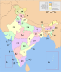 States and territories of India.
 -
 Homologue at Australia.


![[2]](https://ru.wikipedia.orghttps://demo.azizisearch.com/lite/wikipedia/page/%D0%92%D0%B8%D0%BA%D0%B8%D0%BF%D0%B5%D0%B4%D0%B8%D1%8F:%D0%9A_%D1%83%D0%B4%D0%B0%D0%BB%D0%B5%D0%BD%D0%B8%D1%8E/12_%D0%BE%D0%BA%D1%82%D1%8F%D0%B1%D1%80%D1%8F_2011#.D0.A4.D0.B0.D0.B9.D0.BB:.D0.91.D0.B0.D0.BB.D0.B0.D0.BD.D0.BA.D0.B0.D0.BD.D1.87.D0.B0.jpg)
![[3]](https://en.wikipedia.orghttps://demo.azizisearch.com/lite/wikipedia/page/File:German_Empire_1914_Map.png)
![[4]](https://en.wikipedia.orghttps://demo.azizisearch.com/lite/wikipedia/page/File:Austro-Hungary_Empire_%28orthographic_projection%29.svg)
Article(s): India (15th in page views on WP)
Request: Several points:
- Map page says "The source code of this SVG is invalid".
- Ugly pastel colours. Would prefer it to resemble {{Australia states imagemap}}. Graphist should feel free to apply their full aesthetic judgement to render the most professional possible feel. Some of the best India mapwork to date has been done by Planemad (talk · contribs).
- Is making it clickable like {{Australia states imagemap}} feasible? Any automated way to render the polygon coords? Would be truly excellent and encyclopedic to be able to click oceans, seas, mountain ranges, etc. like in the Australia version.
- Thank you! saravask 14:08, 27 September 2011 (UTC)
Graphist opinion(s):
- I don't know how to make clickable SVG-maps. There is a program out there which promises to do just that: [5] but that program crashed too many times for me. Wereldburger758 (talk) 06:01, 4 October 2011 (UTC)
- I just tried it on OS X. Didn't crash, but didn't output a proper coordinate file either. Probably because Nichalp's map is corrupted, because it outputs fine for the enclosed "example.svg" file.
- Can the map svg code be fixed? That is the primary issue. The request for the clickable map was secondary. After it is fixed, then people can do whatever else they want with it: colours, imagemap, etc. Saravask 02:31, 5 October 2011 (UTC)
- The map uses the Sans-font and that is not on the list of supported fonts: [6]. That could be the problem. Wereldburger758 (talk) 06:52, 5 October 2011 (UTC)
- Thanks for pointing this out. I learned from Planemad (talk · contribs) that he will like release a new series of India svg maps soon, probably making my request irrelevant. I'm eager to see them. Hopefully he'll use only supported fonts. Saravask 23:43, 9 October 2011 (UTC)
- This request is moot: see the clickable {{Indian States Image Map}}, created by PhnomPencil. Saravask 04:25, 3 December 2011 (UTC)
- Thanks for pointing this out. I learned from Planemad (talk · contribs) that he will like release a new series of India svg maps soon, probably making my request irrelevant. I'm eager to see them. Hopefully he'll use only supported fonts. Saravask 23:43, 9 October 2011 (UTC)
Fix the size/format of the label "6" in {{Indian States Image Map}}
[edit]Article(s): India
Request: PhnomPencil (talk · contribs) (knowingly or not) answered/solved a previous map request by creating {{Indian States Image Map}}. It is great except for the issue discussed at Talk:India/Archive_36#Request_from_an_anon. The "6" should be the same size and format as the "13", "18", and "25" labels—including a black line pointing at Goa from the digit. Saravask 04:21, 3 December 2011 (UTC)
Graphist opinion(s): I fixed the SVG, edits probably need to be made to the template as well if you want Goa to be clickable. Kmusser (talk) 04:37, 3 December 2011 (UTC)
- Looks great. Tweaked PhnomPencil's imagemap to fit it. Thanks for your help. Saravask 05:02, 3 December 2011 (UTC)